Resources
🔷 Register to have FREE download access to full-sized, high-resolution scans (800 dpi) and detailed information about each projectile point.
🔷 Use Mozilla Firefox™ for the best experience and proper layout for printing. Other browsers give less than an optimal experience for print layout.
🔷 Use the latest, up-to-date browsers. Older browser versions may work, but are not supported.
🔷 Currently, one can Search for projectile points by Latitude-Longitude, Grid Number, Site Number, Shape, Material, or Serration.
🔷 Attribution for articles, papers, or reports that are published using data from this website — must cite this website:
Coal Creek Research, Inc.
[year] Colorado Projectile Point Database, https://p3.coalcreekresearch.org, accessed [month day, year].
Projectile Point Density Map
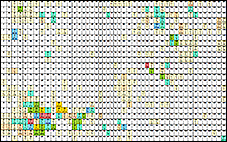
View the Distribution and Count of projectile points within Colorado
Grid Numbers
🔶 Grid numbers range from 1 to 1760 and correspond to the USGS 1:24,000-scale (7.5') topographic maps for Colorado.
USGS Topo Maps and Latitude-Longitude Locator
🔶 Find your Colorado topographic map names, or your topographic map latitude-longitude coordinates.
🔶 The USGS topo map locater is NOT connected to the Colorado Projectile Point Database.
🔶 After you click the “USGS topoView map Name ...” link below:
- In the sidebar at the upper-right of the web page:
- Click the “Map Name” tab.
- Click the “24K” red circle (for the 7.5' topo names).
USGS “topoView” map Name and map Latitude-Longitude locator — COLORADO
Southwestern U.S. Chronometric Databases
🔶 Radiocarbon Database and Tree-Ring Database for archaeological sites located in Southwestern United States - Dominguez Archaeological Research Group.
Documents
🔶 Projectile Point Identification, Completeness, and Lithic Material guides:
Projectile Point IDENTIFICATION Guide - CCR
🔶 Grid Number locations and corresponding topographic map name guides:
🔶 FIXES in CCR documents — several corrections were made from the 1995 USGS Map Name Index for Colorado.